
Love 4WD and Camping Adventures?
You Need to Visit The Fantastic Kroombit Tops National Park
Kroombit Tops National Park is for those of you who love awesome off-road adventures and camping among nature. Located around 80km east of Biloela in Outback Queensland, It’s also 90km north from Monto and 70km south of Calliope. A link to a free Kroombit Tops map and info on Kroombit Tops camping and the Kroombit Tops plane crash site is provided a little further down.
Forever in my memory as the first place I ever got a leech, Kroombit Tops is a lot of fun. Can you believe I managed to reach the age of 38 before ever getting a leech? To be clear, the whole National Park is not full of leeches. However, there is a smaller tropical rainforest section that most definitely, is home to these small, slimy bloodsuckers.

Keep reading so as to discover the highlights and download a free Kroombit Tops map. You will also find information on the Kroombit Tops plane crash site, Kroombit tops camping, 4WD tracks and short walks.
Highlights of Kroombit Tops:
- Find the 1945 crash site of Beautiful Betsy, a WWII Bomber that lay undiscovered for 50 years.
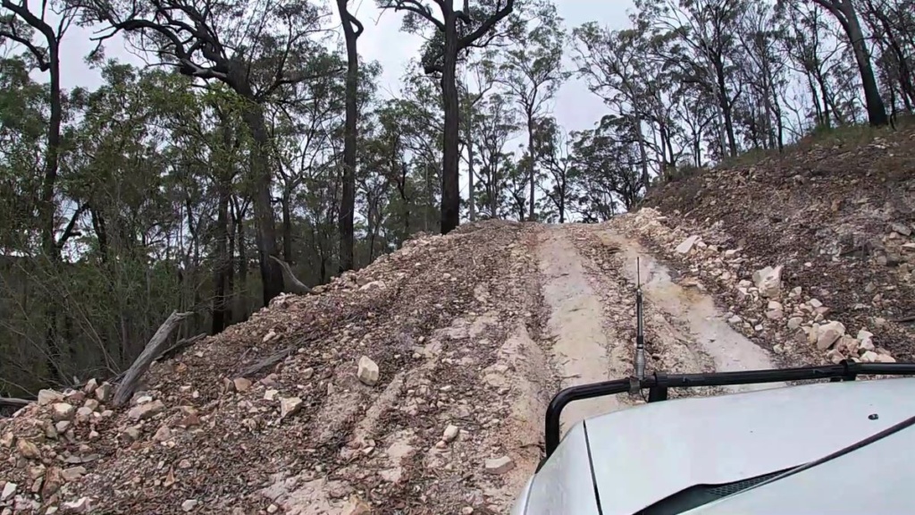
- Fun 4WD tracks for high-clearance 4WD only.
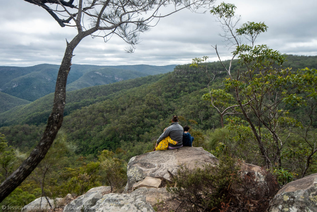
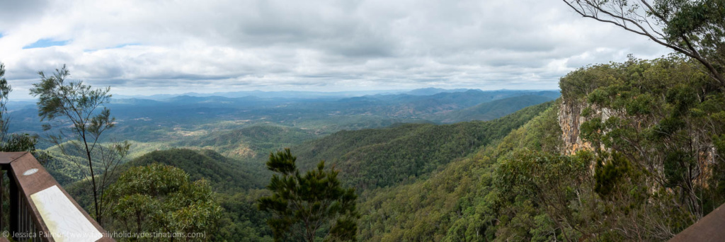
- Amazing views from various lookouts.
- The Marble Waterhole.
- Back to nature self-sufficient camping.
- Bushwalking in sub-tropical open rainforest and blackbutt forest areas.
- Plenty of native wildlife including the endangered Kroombit Tinkerfrog.
Kroombit Tops Plane Crash Site
”Beautiful Betsy”, an ill-fated WWII Liberator Bomber crashed at Kroombit Tops in 1945. However, it wasn’t discovered until 50 years later by a park ranger who saw a glint of the wreckage from some distance away. Access to the crash site is by high-clearance 4WD only and there is excellent signage and a short walking track that tells Beautiful Betsy’s story as you stroll through the wreckage.
The Bomber crash site at Kroombit tops is around 20km one-way from the Tableland Road/Loop Road. The road is mostly narrow so as a result, if there is oncoming traffic, you will have to pull over off to allow others to pass.

Kroombit Tops Map
There is no phone or internet reception for most of Kroombit Tops so you will need to download maps for the region before you get there. A PDF printable map can be downloaded from >>HERE<<.
Kroombit Top National Park 4WD Tracks
The Razorback Track
The Razorback Track is 27km one-way beginning at the Valentine Plains Road entrance and takes around 2 hours. A high-clearance four-wheel drive and experience is required for this track too. This track includes creek crossing, narrow sections and some steep ups and down and for this reason, should only be attempted in dry weather. Expect fantastic views!
Make sure to check out the Kroombit Tops Map link above before you go as receptions is virtually nil!
The Loop Road
The Loop Road is a 35km circuit that takes around 2 hours. High clearance four-wheel-drive is required and it’s not suitable for inexperienced four-wheel-drivers. The track to ”Beautiful Betsy”, the Kroombit Tops plane crash site is found on a track that veers off this track.
Stop at the Wall for your picnic lunch and as you head north to complete the loop, enjoy amazing views of the surrounding gorges and valleys from two natural lookout points.
Nature Walks
There are three short easy-peasy walks suitable for families with younger kids and one longer hike of 13km, or five hours one way.
The Rainforest Walk
The Rainforest Walk meanders 300 m return along a defined track through an unusual tropical rainforest located in Kroombit Tops National Pak. This track contains small leeches. Ugghh I learnt this the hard way when I found one had made it’s way up my pants onto my knee. Needless to say, there was a lot of squealing (from me) and a lot of laughing (from my husband and kids).
Other than the leech fiasco, the walk was really beautiful!
The Lookout Walk
The lookout walk is a simple 100 m return track that leads to a platform featuring amazing views from the eastern escarpment looking over the Boyne Valley.
Beautiful Betsy Crash Site Loop
Once you make it to the Kroombit Tops Plane crash site, families can meander the 700 m return track the debris of the actual plane crash. There is excellent signage here and it’s really interesting!
The Escarpment Track
The escarpment track is a 13km one-way (around five hours) track from Griffith Creek Picnic Grounds to The Barracks. The track follows the eastern escarpment through open blackbutt forest and because the track is a little long to walk all the way back, most people arrange for someone to pick them up at the other end.
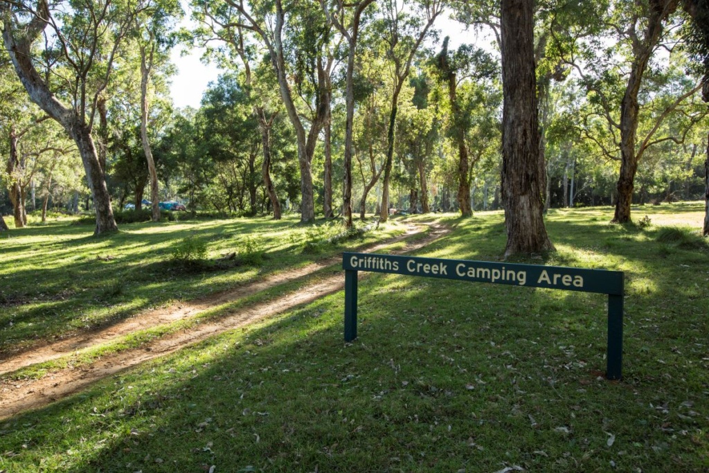
Kroombit Tops National Park Camping
The three campgrounds at Kroombit Tops offer no facilities. Consequently, this means that campers must be completely self-sufficient with their own drinking water, timber, rubbish and toilet. Campsites can be booked >>HERE<< on the QLD National Parks booking site.
Also, don’t expect mobile phone reception in the campgrounds. The kids won’t have a choice but to enjoy nature!
The Wall
The Wall is accessible by the Loop Road (4wd only) and features a grassy clearing on the south bank of Annie Creek. Light your fire in the supplied fire rings within the campsite, which is dominated by a large rocky wall which we all thought was pretty cool!
The Razorback
The Razorback Camping Area is accessible by high-clearance 4WD only and is found on the Razorback Track around a couple of kilometres past the turnoff from Tableland Road. This is a small secluded camping area surrounded by a tall blackbutt forest. Fire rings are provided.
Griffiths Creek
In dry conditions, Griffiths Creek camping area can be accessed by a conventional vehicle and is found on Tableland Road, a few kilometres south of The Barracks. This site is a flat open grass around 100 m from Griffiths Creek and there are no defined sites. Fire rings are provided here.
Credit – Tourism & Events QLD – Katrina Elliott
More Information
Look out for horse riders, hikers and mountain bike riders because some roads within Kroombit Tops National Park are shared with the Bicentennial National Trail. Expect to see cattle on the road at some point and many roads are impassable in the wet.
Check out the QLD Park’s page on Kroombit Tops National Park for more information.
Check Out Our YouTube Clip of Kroombit Tops
Pssst: Check out our post on the nearby Cania Gorge National Park, it’s pretty cool too!
Where to next?

Let me know what you think!