Updated 7th June 2026
The Mereenie Loop Road is one of Australia’s most iconic outback drives, linking the West MacDonnell Ranges with Kings Canyon and providing a rugged shortcut between Alice Springs and Uluru. Expect corrugations, red dirt, remote landscapes, swimming holes, wild brumbies and some of the best scenery in Central Australia. I’ve driven the route twice, and it’s one of my favourite road trips in Australia.

If you’ve been researching the Mereenie Loop and noticed that some websites and maps call it the Red Centre Way, don’t panic. It’s actually the same iconic journey. The Red Centre Way is the full route linking Alice Springs, the West MacDonnell Ranges, Kings Canyon and Uluru. The “Mereenie Loop Road” is simply the unsealed section between the West Macs and Kings Canyon. However, to confuse things, the longer Red Centre Way is often called “The Mereenie Loop”.
In this article, I’ll refer to this back route road trip between Alice Springs and Uluru as both the Mereenie Loop and the Red Centre Way.
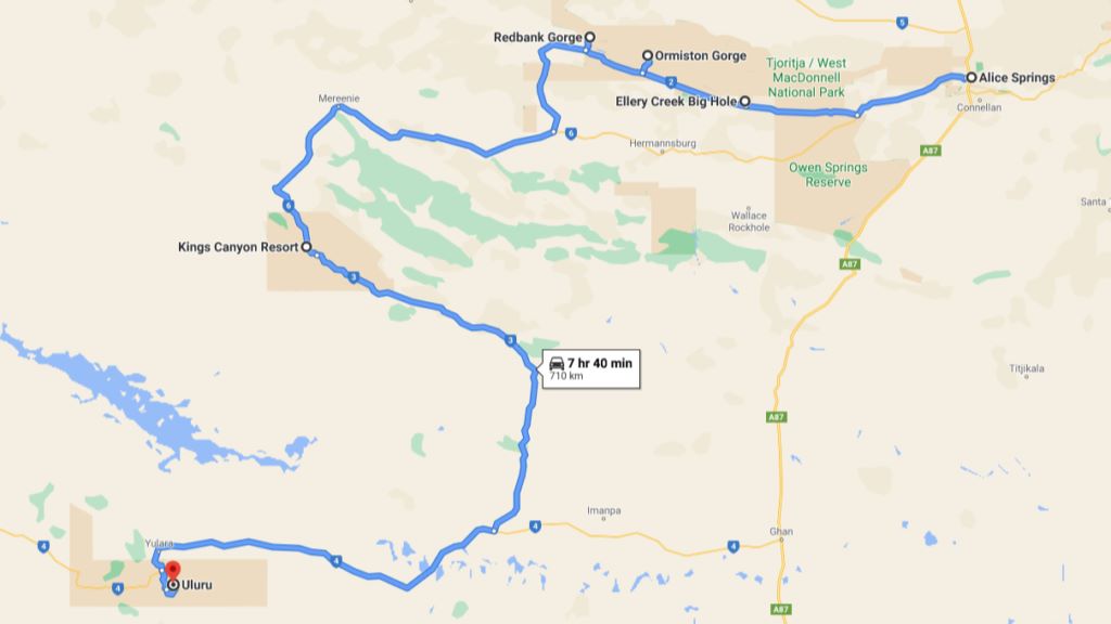
Mereenie Loop map
Whatever name you use, this is one of Australia’s great outback road trips. Think red desert landscapes, hidden gorges, sacred Aboriginal sites, incredible swimming holes, brumbies on the roadside and that unmistakable Central Australia light. I’ve done this route twice now, and both times it was an absolute highlight.
Watch the Mereenie Loop highlights
Want a quick look at what the Mereenie Loop is really like? Here’s a short video of the best stops and scenery along the Red Centre Way.
4WD vs 2WD on the Mereenie Loop (road conditions)
Let’s be clear – this route requires a 4WD. Only one section is officially unsealed (the Mereenie Loop Road itself), but it features corrugations, washouts, loose gravel and soft sand. You’ll see a few determined 2WD vehicles having a crack, but it isn’t recommended.
On both trips, we rattled bolts loose on our rooftop tent, which gives you an idea of how rough it can be.
Mereenie Loop Permit
Everyone who travels the Mereenie Loop must have a permit to drive the Mereenie Loop Road. It’s available from the Alice Springs Visitor Information Centre and at $5.00 per vehicle, it’s not going to break the bank. The permit is valid for three days and you are not allowed to camp overnight on the Mereenie Loop Road.
However, there is plenty of other camping options along the way in the West MacDonnell Ranges, and at Kings Canyon and Uluru.
Alternatively, you can also get a Mereenie Loop permit for various prices from Glen Helen Lodge, Hermannsburg General Store, Kings Canyon Resort reception, Kings Creek Station and the Alice Springs Central Lands Council.
How long does the Mereenie Loop take?
Allow at least five days to enjoy the Red Centre Way without rushing, but if you have longer, take it. We’ve done both a five-day version and a ten-day version, and the longer one was far more enjoyable.
The return trip to Alice Springs from Uluru via sealed roads takes around 4.5 hours.
Mereenie Loop itinerary (flexible guide)
Below is a loose itinerary you can shape to suit your pace. During peak season, pre-book accommodation at Alice Springs, Glen Helen, Kings Canyon and Uluru. Even if you’re just wanting to camp in their caravan sites. National Park Camping sites can be found at Ellery Creek Big Hole, Ormiston Gorge, Finke 2 Mile and Redbank Gorge. These can only be booked online, so it’s best to do it while you have phone reception in Alice Springs.
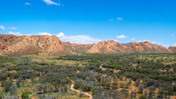
Alice Springs → West MacDonnell Ranges
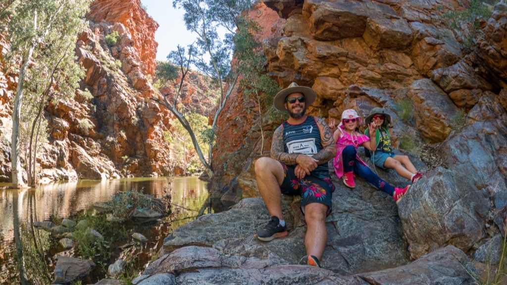
This stretch is an absolute stunner and also where you’ll find many of the Red Centre’s best waterholes. Expect deep gorges, dramatic rock formations and some of the best swimming holes in the country.
Simpsons Gap
Just 28km from Alice Springs along Larapinta Drive, Simpsons Gap is one of the most prominent gaps in the West MacDonnell Ranges and Mereenie Loop road trip. Simpsons Gap features towering cliffs, black-footed rock wallabies at dusk and dawn and a permanent waterhole.
Standley Chasm (Angkerle Atwatye)
50km west of Alice Springs on Larapinta Drive, Standley Chasm is located in a private reserve owned by the Iwupataka Land Trust, a unique Aboriginal-owned and operated enterprise. The Angkerle Aboriginal Corporation is owned by the local community members who are direct descendants of the Arrernte Aboriginal people who have lived in this area for tens of thousands of years.
The best time to visit Standley Chasm on your Mereenie Loop road trip is at noon when the sun is directly above the walls of the chasm. The sun’s rays magically change the walls from a dullish brown to a glowing orange. There is a cafe on-site as well as picnic tables, BBQs, campsites and toilets.
Ellery Creek Big Hole
Turning onto Namatjira Drive from Larapinta Drive, Ellery Creek Big Hole is 90km west of Alice Springs. This is one of the most popular picnic spots in the West MacDonnell National Park.
Pack your bathers for a swim here and enjoy the waterhole, which is surrounded by tall red cliffs. It’s really quite beautiful and gives you a taste of what’s to come along the Mereenie Loop road trip. Make sure you do the three-kilometre Dolomite walk to see the surrounding formations and take in some great views.
Camping is available here through the Northern Territory National Parks booking website.
Serpentine Gorge
Following the same road west, Serpentine Gorge is 102km from Alice Springs. This narrow gap in the West MacDonnell Ranges creates a stunning oasis. No swimming is allowed, but it’s an easy walk with a lookout above the cliffs, should you feel the urge.
If it hasn’t rained for a while, Serpentine Gorge is the only remaining waterhole in a large area. As a result, there are plenty of great bird-watching opportunities. Don’t miss this nice side trip on the Mereenie Loop.
Ochre Pits
Just a little further west down Namatjira Drive are the vivid colours of the mineral Ochre Pits, which have been mined for generations by the local Aboriginal people.
There is an information shelter here with signage explaining how, why, and when the Ochre Pits were used. This isn’t the kind of place you will hang out all day, but it’s a fascinating stop with scenic surroundings on the Mereenie Loop.
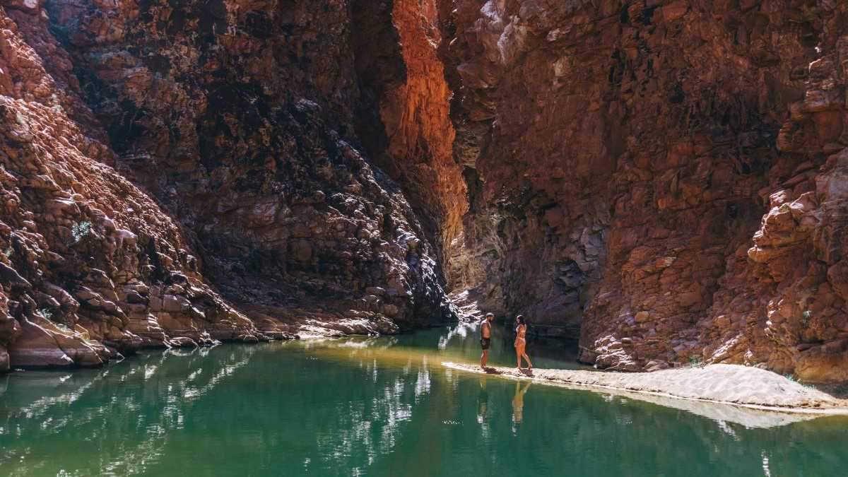
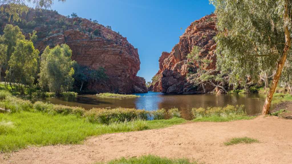
Ormiston Gorge
Now, this is definitely a place you will want to hang out and stay overnight at on your Mereenie Loop road trip. Ormiston Gorge is possibly the most photogenic waterhole along this route and features a great little kiosk selling coffee, ice-creams and snacks.
It’s a stunning spot with a near-permanent waterhole around 500 metres from the visitor centre that is just perfect for swimming. Take a short but sweaty 20-minute walk up to the lookout, or hike the Ormiston Pound Walk, a more challenging 3-4 hour circuit.
Camping is available here through the Northern Territory National Parks booking website. The bathrooms even feature a hot shower large enough to take the kids in with you.
Glen Helen Gorge and Glen Helen Resort
Glen Helen resort has been revamped by Discovery Parks and is the only non-camping option in the West MacDonnell Ranges. However, if you do want to camp, there are campsites here as well.
The gorge and waterhole itself are beautiful and even if you aren’t staying overnight here, it’s worth a stop to check it out.
Finke 2 Mile
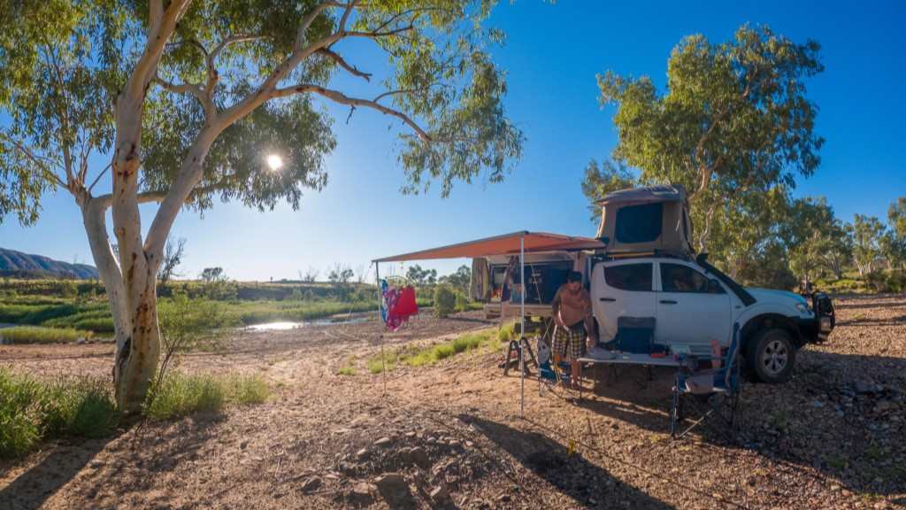
Finke 2 Mile is a hidden gem in the West MacDonnell Ranges. The sign is on the right, just past Ormiston Gorge and Glen Helen, and is absolutely 4WD access only. It’s a beautiful spot to camp, but there are no facilities here so you’ll need to be completely self-sufficient with your own toilet and water.
Camping is available here through the Northern Territory National Parks booking website.
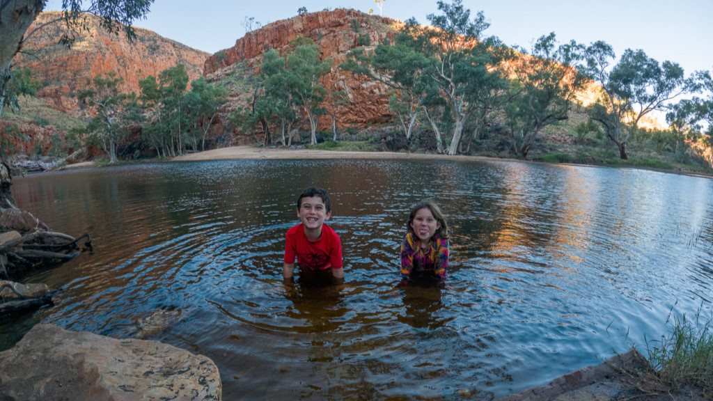
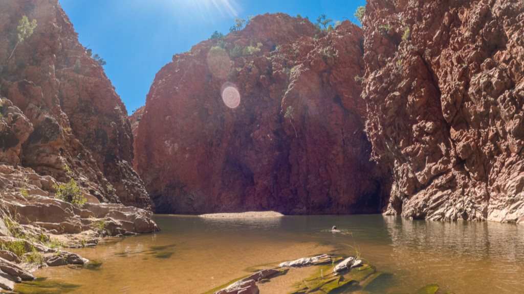
Redbank Gorge
Redbank Gorge is stunning and is by far, my favourite swimming spot on Mereenie Loop. Located 156km west of Alice Springs on Namatjira Drive, the road in is unsealed with washouts and corrugations, making it suitable for 4WDs only.
There is a walk from the carpark to the waterhole where you can swim but conditions vary with the season. The first time we did this, it was an easy 30-minute walk up the dry, sandy river bed with a small amount of rock scrambling. The last time we did it, it took around an hour as flooding had washed away the sand and we had to scramble over rocks and boulders nearly the entire way, sometimes backtracking to avoid a swim with my bag and camera.
Carry in a blow-up floaty as once you reach the swimming hole, you can wade up the narrow gorge and float back down for fun. Nowhere else on the Mereenie Loop can you experience this!
There are two campgrounds here, the Woodland and the Ridgetop, and both have toilets, fire pits and picnic tables. Sites can be booked through the Northern Territory National Park booking website.
Tnoralla (Gosse Bluff)
198km west of Alice Springs, Tnorala (Gosse Bluff) doesn’t get many visitors and is culturally significant to the Western Arrernte Aboriginal people. Scientists believe that around 142.5 million years ago, a comet approximately 600 metres wide crashed into earth and blasted a crater around 20 kilometres across. Today, due to erosion over millions of years, the land surface is about five kilometres in diameter and two kilometres lower than the original impact.
Once you see the sign and drive in, it is strictly 4WD-only over both soft sand and corrugation. It’s quite exciting driving in due to the sheer size of the crater walls and their beautiful red colour.
Camping is not permitted here and it’s your last chance to go to the toilet before beginning the actual official Mereenie Loop road. I highly recommend doing the short walk to the lookout.
The actual Mereenie Loop Rd
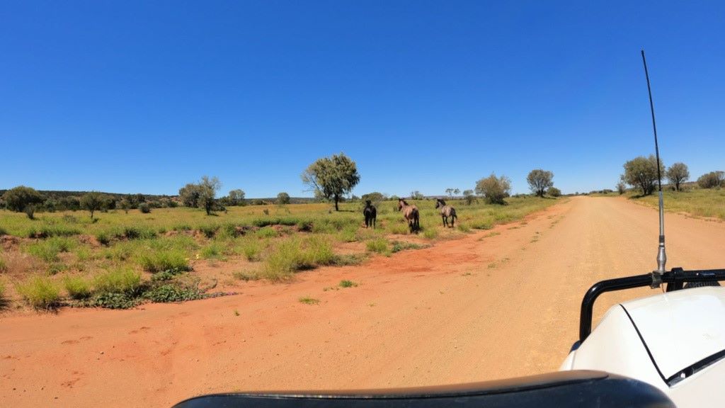
As mentioned earlier, the actual road called the Mereenie Loop (which is a small section of the much larger road trip route by the same name) is unsealed and is your fun ”shortcut” through to Kings Canyon. Make sure you have your Mereenie Loop permit organised and let your tyres down to better manage the corrugations. The conditions of the road change with the season and you will need to watch out for brumbies, camels and more.
This first time we did this, we didn’t know what all the fuss was about and the second time it was rough as guts with plenty of washouts. Both times we rattled some hinge bolts loose on our rooftop tent.
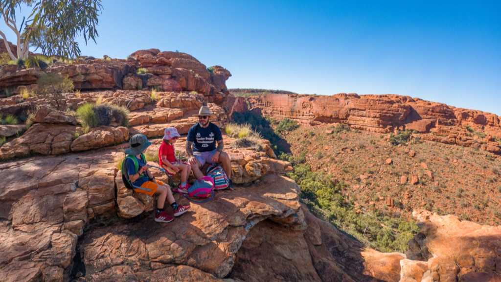
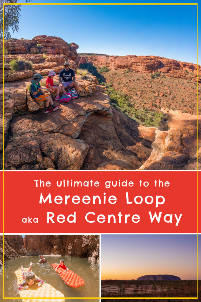
Kings Canyon in Watarrka National Park
Kings Canyon is one of the great walks in Central Australia. I recommend doing both the Rim Walk (6 km), which is a bit of a challenge, and the Kings Creek Walk (2.6 km return), which is easy. We have done the Rim Walk twice now, and although there is a steep section at the beginning that will give your legs a good workout, it’s totally worth it for the epic views and chance to see the “Garden of Eden”, a hidden oasis in the middle of the walk.
If you need a break from camping at this point, the glamping tents at Kings Canyon Resort here are a nice way to recoup. However, the camping sites here are also great with a resort pool and a nearby sunset-viewing platform.
Kings Canyon → Uluru–Kata Tjuta National Park
Follow Luritja Road to the Lasseter Highway, then continue to Uluru – Kata Tjuta National Park. This section is around 300km and fairly uneventful – until, of course, Uluru appears on the horizon.
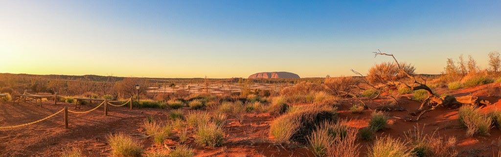
When you spot Uluru for the first time in the distance, it’s hard not to feel a sense of wonder, and it’s even better up close. Exploring Uluru and Kata Tjuta is the grand finale of the Mereenie Loop. Cycling the base track at Uluru is a brilliant way to see it, and the Valley of the Winds Walk at Kata Tjuta is unforgettable.
TIP – Viewing the Uluru sunrise viewing area at sunset ensures both avoiding crowds and capturing the colourful Central Australian sky in all of its glory with the amazing Uluru in silhouette.
Back to Alice Springs
Exploring the Uluru – Kata Tjuta National Park marks the end (sort of) of your amazing Mereenie Loop road trip. Head straight back up the Stuart Highway to Alice Springs (around 4.5 hours without stops) to finish up your holiday and complete the Mereenie Loop. If you have more time and a 4WD, consider exploring both the East MacDonnell Ranges and/or Palm Valley back toward Alice Springs.
Is the Mereenie Loop worth it?
Absolutely.
I’ve now driven the Mereenie Loop twice, and if I ever return to Central Australia, I’d happily do it again. Sure, taking the sealed highways between Alice Springs, Kings Canyon and Uluru is easier, but you’d miss many of the places that made this trip so memorable.
For me, the highlights weren’t actually Uluru or Kings Canyon. They were swimming at Ormiston Gorge, floating through the narrow water-filled gorge at Redbank Gorge, camping at the secluded Finke 2 Mile campground and stumbling across wild brumbies on the side of the road. These are the sorts of experiences you simply don’t get by sticking to the main highways.
The Mereenie Loop also gives you a much better appreciation for the vastness and beauty of Central Australia. One moment you’re swimming in a waterhole surrounded by towering red cliffs, the next you’re bouncing along a dusty track with not another vehicle in sight. It feels remote, adventurous and uniquely Australian.
That said, this isn’t a drive for everyone. If you hate corrugations, don’t enjoy remote travel or are nervous about driving on gravel roads, you may find the Mereenie Loop more stressful than enjoyable. Road conditions can vary dramatically depending on when the road was last graded and recent weather.
But if you have a capable 4WD, a sense of adventure and a few extra days to spare, I think the Mereenie Loop is one of the best road trips in Australia. In my opinion, it’s not just a way to get from Alice Springs to Uluru – it’s a destination in its own right.
FAQs about the Mereenie Loop (Red Centre Way)
Yes. A 4WD is required for the Mereenie Loop due to corrugations, washouts, and unsealed sections. Some people take 2WDs, but it isn’t recommended.
Most travellers take 4-6 days to enjoy the Mereenie Loop route from Alice Springs to Uluru. You can return to Alice Springs in around 4.5 hours via sealed highways.
Yes. A Mereenie Loop permit is required and can be purchased cheaply from the Alice Springs Visitor Information Centre.
Pretty much. “Red Centre Way” is the tourism name for the broader Alice Springs-West Macs-Kings Canyon-Uluru route. However, to confuse things, this route is also called the “Mereenie Loop” after the “Mereenie Loop Road”, an unsealed section between the West Macs and Kings Canyon.
Highlights include Standley Chasm, Ellery Creek Big Hole, Ormiston Gorge, Redbank Gorge, Tnorala (Gosse Bluff), Kings Canyon, and Uluru.
There is camping along the greater Mereenie Loop/Red Centre Way route in the West MacDonnell Ranges and commercial campgrounds at Glen Helen, Kings Canyon and Uluru. However, camping is not allowed along the smaller unsealed stretch of track called “Mereenie Loop Road”, which you’ll drive on when doing the Mereenie Loop/Red Centre Way road trip.
They dry season (May – September) offers the most reliable road conditions and comfortable temperatures for walking and swimming. Swimming is easier towards September when its warmer as the waterholes are always chilly.
This article contains affiliate links to products. We may receive a commission for purchases made through these links.
Where to next?
📌 Save this article to Pinterest so you’ll have it handy when planning your own trip.

Let me know what you think!